Re-Capture the Alamo!
Langan Laser Scans One of America’s
Most Famous Battle Sites
View Langan’s 3D laser scans and models of historic projects.
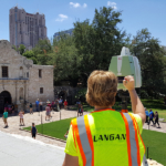
Last month, Shaun Higgins and a Langan team completed a historic mission—they captured the famous Alamo. Well, “captured” it using 3D laser scanning technology, that is. As a result, planners now have a much more efficient means to preserve the structure at the heart of the Alamo Master Plan, which encompasses a 50-acre site in San Antonio.
Higgins’ team prepared a high-resolution, true-color 3D point cloud of the Alamo church and long barracks buildings, as well as the areas surrounding these buildings on the Alamo plaza. Langan used a combination of mobile mapping and terrestrial 3D laser scanning to locate the existing site features of the exteriors of the entire area, the interiors of the historic buildings, and a group of adjacent retail buildings. The mobile mapping and terrestrial laser scanning point clouds were all georeferenced on a network covering the entire project area, including interiors of scanned buildings. The level of detail acquired during the field scans will give historical preservationists the ability to identify stone patterns and details previously undetected.
“It was thrilling to visit, let alone scan, the Alamo, one of the most well-known and revered places on the planet,” said Higgins, a Langan Associate, and one of the firm’s leaders in 3D Laser Scanning/Modeling. “Our practice takes us to a wide variety of locations, ranging from complex renovations for hospitals and hotels to notable historic buildings that require the precision that only laser scanning can provide.”
In addition to the Alamo, Langan has provided scanning and modeling services to a number of historic and culturally significant projects. View our portfolio of select 3D laser scanning projects.